Westachse
National Socialism: West Axis
The Nazis planned to remodel Berlin. Their plans to accommodate a north-south corridor with the “Halle des Volkes” (Hall of the People) and a
“Triumphbogen” (Triumphal Arch) are widely known. The General Building Inspector for the Reich Capital – Albert Speer – also made plans to develop Berlin into a car-centric metropolis. Within the inner city, these plans were realised primarily along the western corridor. Some of these Nazi architectural features are still visible between the Brandenburg Gate and Scholzplatz in Westend, particularly the “Speer Lampposts”. Unbeknownst to most, the Siegessäule (Victory Column) was relocated to its current location at the Großer Stern in 1938/39. The Charlottenburg Gate with the Charlottenburg Bridge are also a product of the Nazi era, as is today’s Ernst-Reuter-Haus and the forecourt of the Technical University. Further west followed Mussolini-Platz (now Theodor-Heuss-Platz) and a vast, new university campus. Completing the western corridor was to be a large-scale world exhibition centre planned for Pichelswerder island.
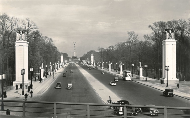
The western corridor lined with Speer’s lampposts and festive decorations, 1939
In 1939, the first extension of the western corridor between the Siegessäule (Victory Column) and Tiergarten S-Bahn station was completed, forming the main parade route for the Nazi dictatorship. The project was the first public construction project undertaken by General Building Inspector Albert Speer as part of the “remodelling of the Reich capital.”
Along the Via Triumphalis from the Chaussee to Charlottenburg
The western corridor extension project between the Brandenburg Gate and today’s Theodor-Heuss-Platz, began with the remodelling of the road. The 7.4-kilometre-long road was widened to 50 metres between November 1937 and April 1939. The carriageway was 33 metres wide with a central reservation and had Speer’s monumental lampposts running along its entirety. The section of road between the Brandenburg Gate and today’s Ernst-Reuter-Platz was further embellished with pillars and pylons, to better mark the Nazi marching route.
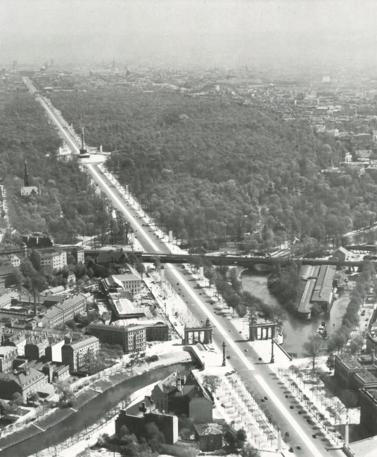
The western corridor between the Brandenburg Gate and the Technical University (today: TU Berlin), 1939
In the foreground of this aerial view is the S-Bahn subway that was rebuilt as part of the project to widen the road to 50 metres. The new bridge over the Spree and the widened Charlottenburg Gate are also visible.
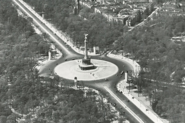
The newly designed Großer Stern with the Siegessäule (Victory Column), relocated here from Platz der Republik, 1939
The square gained its 200-metre-wide monumental circular shape during the extension of the western corridor. The installation of the Siegessäule (Victory Column), which had been altered in size and proportion by Albert Speer, accompanied by monuments to Bismarck, Moltke and Roon, turned the Großer Stern into the “Forum of the Second Reich”.

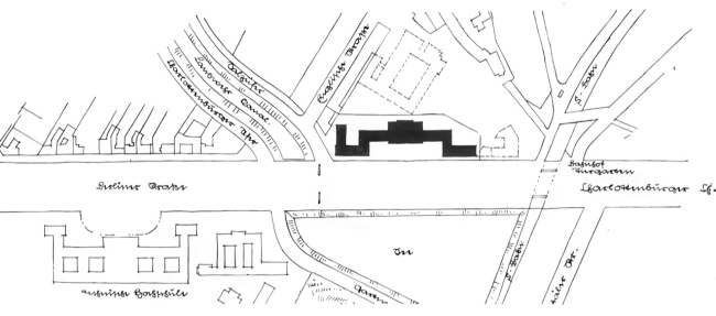
Haus des Deutschen Gemeindetages (today Ernst-Reuter-Haus), designed by Walter Schlempp with Karl Elkart, model and site plan
This monumental building, erected between 1938 and 1942, was the first large building to be built along the western corridor in line with the redevelopment plan. Its architectural design set a precedent for other buildings that would be built along the route.
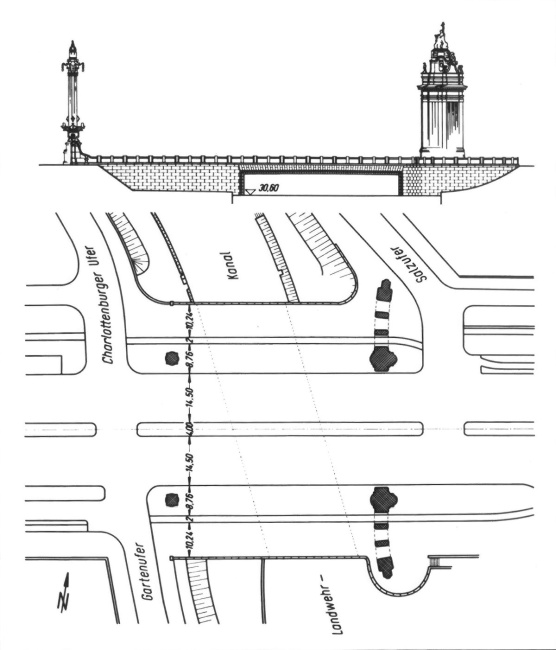
Charlottenburg Bridge with the Charlottenburg Gate, view and site plan, 1938
The extending of the western corridor to 50 metres meant the Landwehrkanal Bridge also had to be widened and the Charlottenburg Gate repositioned.
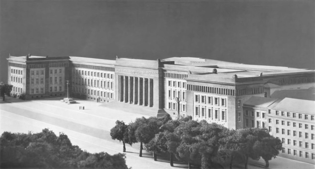
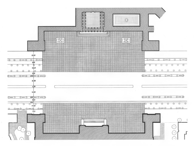
Haus der Deutschen Ärzteschaft, designed by Carl Cramer, model and site plan, 1938/39
The large building, opposite the main site of the Technical University, was set to border a granite-paved square on which the grandstands for military parades would be installed. The design was left unrealised on account of the war.
From Adolf-Hitler-Platz to Mussolini Station
Today’s Theodor-Heuss-Platz – named Reichskanzlerplatz until 1933, and Adolf-Hitler-Platz between 1933 and 1945 – was to be completely transformed as part of the development of the western corridor. At Hitler’s request, the square was to feature a colossal monument dedicated to Mussolini. The designs also planned to convert Heerstrasse S-Bahn station into a state railway station named after Mussolini. Whilst both Mussolini-Platz and Mussolini station were not realised due to the war, a number of large buildings were constructed on this section of the corridor, which give a hint of the architectural direction.
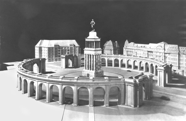
Model of the Mussolini monument for Adolf-Hitler-Platz (until 1933 named Reichskanzlerplatz and today Theodor-Heuss-Platz), designed by Albert Speer, 1939
Once this monumental memorial site with its sculpture of a warrior by Arno Breker was completed, the square was to be renamed Mussolini Square at Hitler’s request.
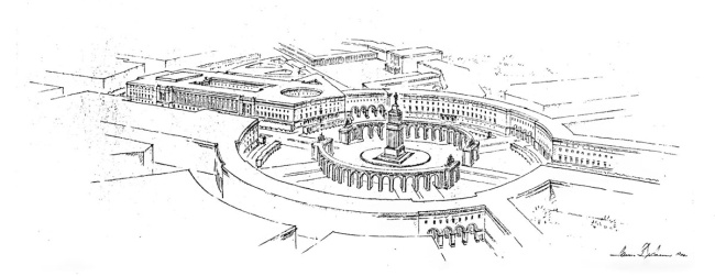
Illustration of Mussolini Square with its memorial site (designed by Albert Speer) and the Reichsrundfunkhaus (Reich Broadcasting Centre, designed by Hanns Dustmann), as planned in 1940
Dustmann planned to demolish the traditional architecture of the square, favouring a design featuring two uniform half-arches surrounding the memorial.
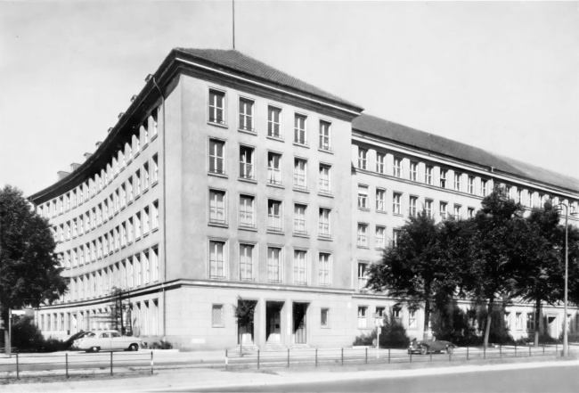
Office building between Bayernallee and Württembergallee, designed by Paul G. R. Baumgarten and Paul Emmerich, built 1938–1941
This building complex was constructed in two phases. The western section was built to house the offices of Philipp Holzmann AG and the larger eastern section, completed in 1941, was the Reich headquarters of the Hitler Youth.
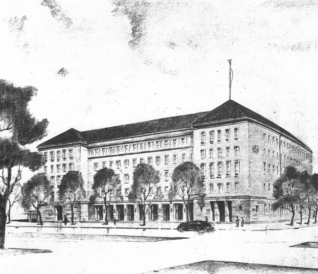
The head office of Schultheiss Brewery A.G., designed by Werner Lattermann, built in 1938/39
The architect’s drawing shows the completed building on the corner of Württembergallee. Its architectural design is based strongly on that of the neighbouring building complex designed for Philipp Holzmann and the Hitler Youth.
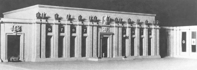
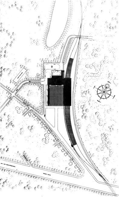
Mussolini state railway station, a model of the station building and site plan, designed by Theodor Dierksmeier, as planned in 1940
On Hitler’s orders, the Heerstrasse S-Bahn station was to be converted into a station named in honour of “il Duce”, as this was where he was received on a state visit to Berlin in September 1937.
The Large-Scale Plans for the University Campus and the World Exhibition Centre
The large-scale “Hochschulstadt” (university campus) project was designed as the pinnacle of the western corridor extension after Mussolini-Platz. The General Building Inspector organised a public competition for its design in December 1937. However, the planning of the campus dragged on until the beginning of 1943 and it was ultimately never realised. Only the Department of Military Technology was completed as a shell after it had been left out of the complex building programme due to the war preparations that began at the end of 1936. Today, it lies in the mountain of rubble that forms Teufelsberg. Even further to the west, an expansive world exhibition centre was planned on Pichelswerder island.
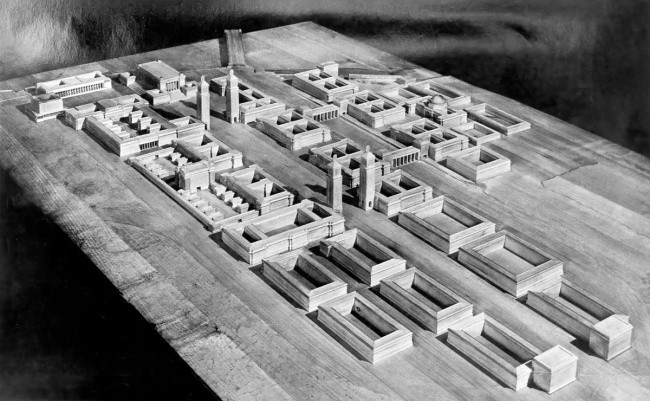
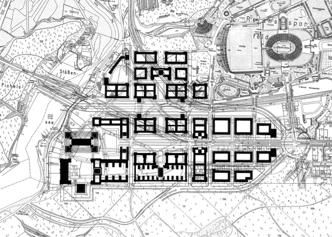
The university campus („Adolf Hitler University“), model and site layout, as planned in 1943
The model and site plan show the final designs for the university campus to be realised by the General Building Inspector. The Reichs Sports Field, which was planned as part of the project, was to make this the architectural crown jewel of the western corridor.
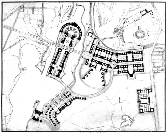
Urban planning design by the General Building Inspector for the island of Pichelswerder to the west of the university campus, according to preliminary plans in 1937/38
The plans for Pichelswerder island included an expansive world exhibition centre that extended across the entire island, incorporating the western corridor. It was to be similar in size to the university campus.
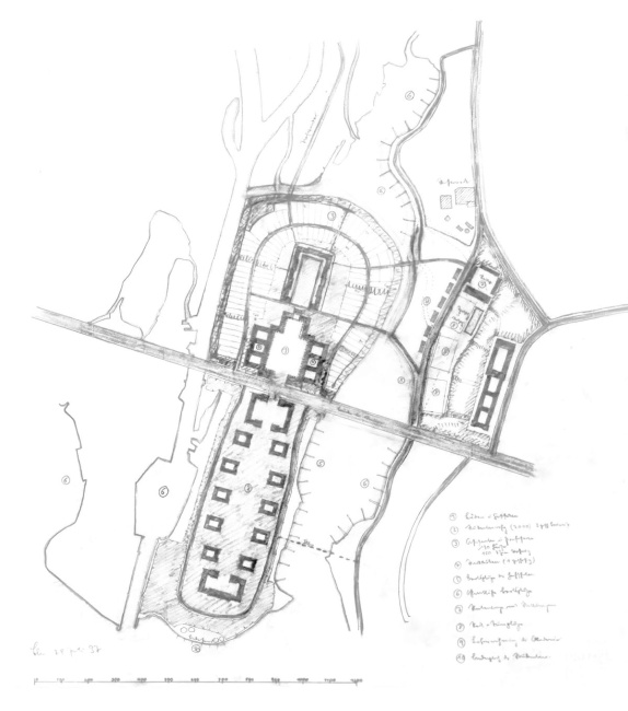
Sketch for the world exhibition centre on the island of Pichelswerder between the Havel river and Stössensee, July 1937
This little-known project was one of the first urban development projects planned by the “General Building Inspector for the Reich Capital Berlin”, who was appointed on 30th January 1937, as part of the expansion project of the western corridor.
The Grand Plan for the “Reorganisation of the Reich Capital”
The western corridor was an integral part of the “redesign plans” that were to transform Berlin into the centre of power of a vast empire by 1950. The planned motorway ring was to mark out the new city boundary. The city centre’s basic structure was formed as a cross, supplemented by four concentric ring roads and a large number of radial roads. These plans, the work of General Building Inspector Albert Speer and their implementation were directly linked to the brutal war of plunder, the extermination of the Jews, their persecution and deportation, and the use of forced labourers.
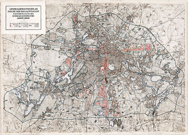
General Building Inspector Albert Speer’s master development, as planned in 1942
The plan shows the final phase of the “reorganisation of the imperial capital”. It reveals the significant role that the east-west corridor played in the highly structured road system with its intersection axes and ring roads.
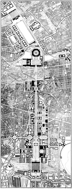
The north-south corridor between Nordbahnhof (above) and Südbahnhof (below), final draft of Speer’s plan from February 1942
The gigantic north-south corridor meets the western corridor to the south of the “Great Square of the Volkshalle”, the western axis extending from Unter den Linden out towards the motorway ring. The striking difference in the dimensions of these roads illustrated the supremacy of the north-south corridor.
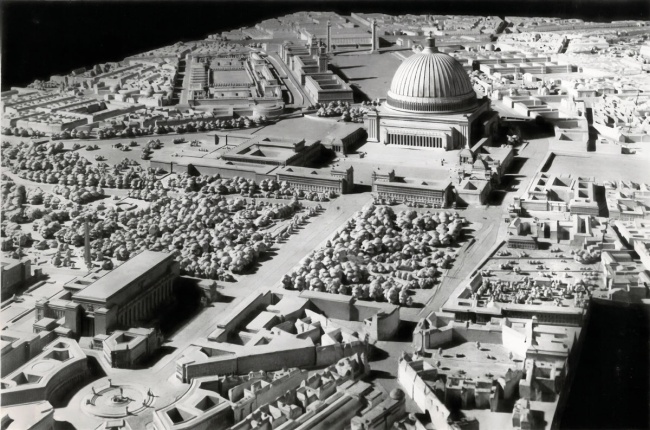
Urban planning model of the intersection of the western corridor and the north-south corridor, as planned in 1940
Arranged along the western corridor are the building complexes of the “New Reich Chancellery” (left) and the “High Command of the Wehrmacht” (right). The developments are similar in style and accentuate the approach to the “Great Square”.
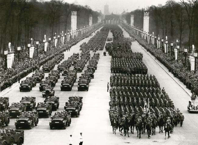
Military parade on the completed western corridor, 20th April 1939
To mark Adolf Hitler’s 50th birthday, members of the Wehrmacht marched along a festively decorated route between the Brandenburg Gate and the Großer Stern. This picture captures the real motivation behind the western corridor expansion, namely as a parade route and stage for the Nazi dictatorship’s demonstrations of power.
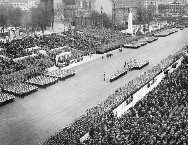
Procession marching in front of the grandstand for the birthday parade, 20 April 1939
The stage was positioned opposite the forecourt to the main building of the Technical University (today TU Berlin). Hitler held the ceremonial military parade here, which lasted more than four hours - an ominous harbinger of the Second World War that would begin that September with the invasion of Poland.
West Axis Today
Due to massive war damage, traffic accommodating measures and reconstruction efforts, today the western corridor is formed by a collection of separate roads. The lane configurations and street lighting systems alternate. New architectural features, including the striking Red Army memorial and the austere front of the main TU building have cropped up along its stretches. Ernst-Reuter-Platz, which has no specific demarcations, creates a clear gap in place of the former “knee” while Theodor-Heuss-Platz, its historical form largely preserved, has been given new architectural character by the building of the RBB (Rundfunk Berlin Brandenburg) high-rise.
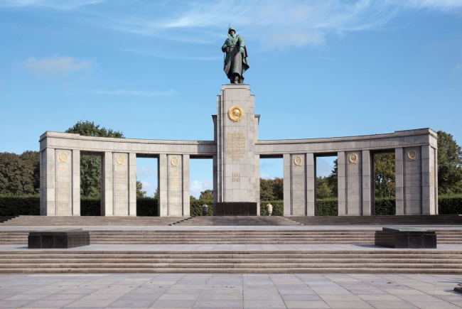
A symbol of victory: Soviet memorial to the Red Army
The memorial and military cemetery was swiftly constructed after the war and inaugurated on 11th November 1945 with a parade of Allied troops. It was designed by sculptors Lew Kerbel and Wladimir Zigal with the architect Nikolai Sergijewski. It was the first structure to be erected in the much damaged capital after the end of the Second World War.
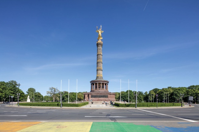
The forgotten NS-Platz: Großer Stern in Tiergarten
Created as a monumental memorial square between 1937 and 1939 featuring a spiral roundabout, the Großer Stern underwent comprehensive renovation works in the late 1980s. At that time, it was given “Schinkel lights” and pseudo-historical street signs in place of Speer’s original lampposts. This has obscured its storied past.
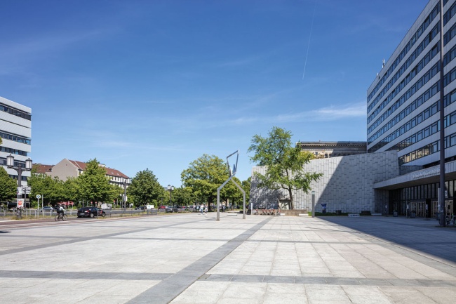
TU Berlin after the war: TU main building with stone forecourt
The smooth, contourless building complex with its asymmetrically attached Audimax was built between 1961 and 1965 according to plans by Kurt Dübbers and Karl Heinz Schwennicke. The uninspiring new building with its shapeless forecourt does not compare to the architectural significance of the old main building.
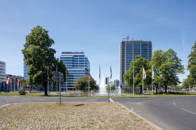
At the mercy of the automobile: the windy square at Ernst-Reuter-Platz
The expansive square, planned from 1956 by Bernhard Hermkes, was lined with standalone buildings. Its enormous multi-lane roundabout dominates the site. In contrast to the old “knee”, the elegant “Telefunken tower” provides a striking architectural accent to this less built-up site.
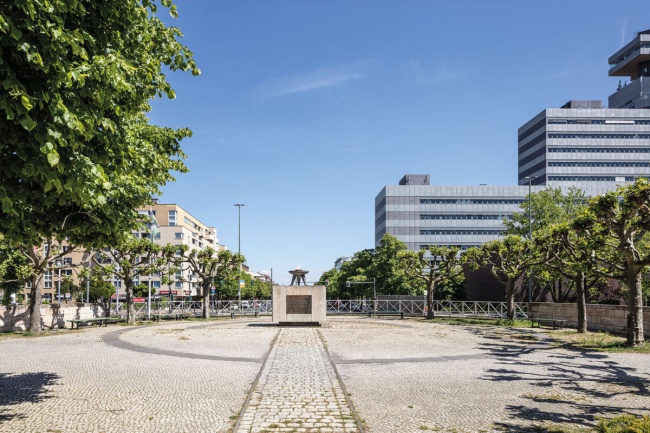
Public art of the square: Theodor-Heuss-Platz, formerly Reichskanzlerplatz and Adolf-Hitler-Platz during the Nazi era
In 1995 the large sculpture “Blue Obelisk” by Hella Santarossa was installed in the centre of the historic square. As early as 1955, the “Eternal Flame”, a memorial to the victims of displacement and expulsion, was erected on its eastern side. This is flanked by two archaic-looking depictions of heads by Rainer Kriester. The RBB high-rise is a modern and distinctive addition to the square.
Key Figures
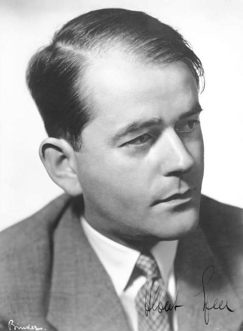
Albert Speer (1905–1981)
After joining the NSDAP in 1931, the qualified architect soon advanced to become the party architect and was appointed “General Building Inspector for the Reich Capital Berlin” (GBI) by Hitler on 30th January 1937. From February 1942, he was “Reich Minister for Armaments and Ammunition” and organised the “total war”. He was sentenced to 20 years in prison at the Nuremberg war crimes trial.
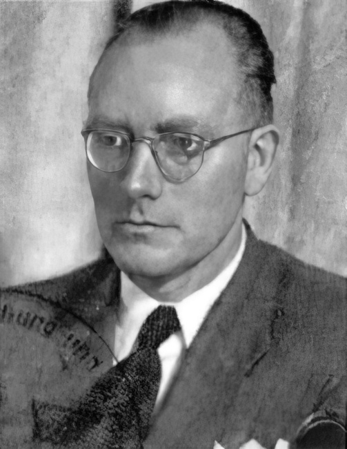
Rudolf Wolters (1903–1983)
After graduating and obtaining his PHD in architecture, Wolters worked for the Siberian Railways in Novosibirsk/USSR in 1932/33. From 1933 to 1936, he worked in the office of his university friend Albert Speer, before being appointed head of the planning department of the General Building Inspector in 1937 and taking over as head of the “Planning Department for the Reconstruction of Bomb-Damaged Cities” in 1943. From 1938, Wolters was a member of the Architekten- und Ingenieur-Verein zu Berlin.
Hanns Dustmann (1902–1979)
The architect worked for Walter Gropius between 1929 and 1933 and then in the Reichsbank construction office. From 1937, he was chief architect of the cultural office and the building department of the Hitler Youth. In 1939, he was appointed “Reich Architect of the Hitler Youth”. He was also responsible for the remodelling of Vienna. He worked in Albert Speer’s office from as early as 1938. In 1944, Dustmann was included in the “Gottbegnadeten-Liste” (list of those honoured by God).